
In a new research article from GEO Mountains, Thornton et al. analyse the coverage of in situ climatological observations across the world's mountains.
In situ climatological data from the world's mountains are crucial for many applications. As such, any limitations associated with such data (e.g., limited spatial density of stations, short record lengths, relative lack of observations at higher elevations, etc.) can impinge upon several important activities, not least tracking changing mountain climates, better understanding the key processes and feedbacks involved, and making reliable projections of change impacts.
Despite this, patterns of in situ climatological data coverage with respect to space, time, and elevation has not yet been assessed in detail on a global basis. To begin to address this gap, in a new GEO Mountains-led research article published in Frontiers in Climate, Thornton et al. used perhaps the most comprehensive global inventory available – Global Historical Climatological Network daily (GHCNd) – to investigate and compare patterns of air temperature, precipitation, and snow depth observation record coverage across 292 named mountain regions.
For the first time, additional datasets were also introduced in order to assess data coverage in more relative terms, for example with respect to the hydrological importance and size of the downstream economy of each mountain range. An 'Open Science' approach, based on exclusively open data and software, was employed throughout. The article involved collaboration with the leads of the MRI's Elevation-Dependent Climate Change and Mountain Observatories Working Groups, and was a contribution to the Frontiers Research Topic 'Knowledge Gaps from the IPCC Special Report on the Ocean and Cryosphere in a Changing Climate and Recent Advances (Volume II).'
The article’s main findings are that:
- Spatial patterns of mountain data coverage are highly uneven (see e.g. Figure 1);
- Station densities in several 'Water Tower Units' that were previously identified as having great hydrological importance to society are especially low (Figure 2);
- A number of mountainous regions whose elevational distribution is severely under-sampled by GHCNd stations could be identified, and;
- Mountain station density is only weakly related to the human population or economic output of the corresponding downstream catchments.
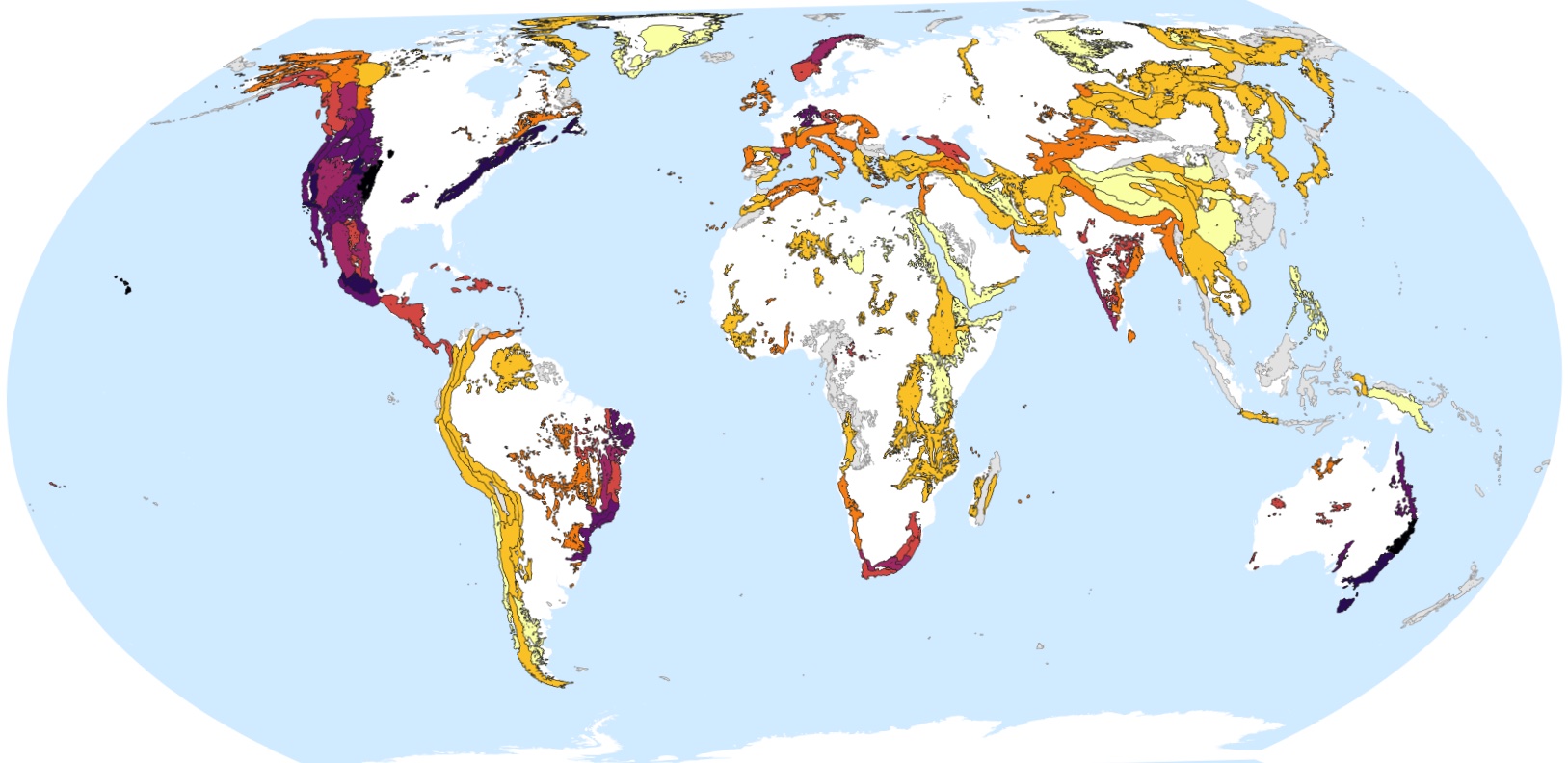
Fig 1: Mean spatial density of precipitation records at mountainous GHCNd stations irrespective of record length (yellow: low, black: high).
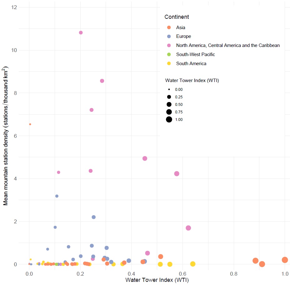
Fig 2: Mean mountain GHCNd station density, irrespective of variable and record length, for each 'Water Tower Unit' (WTU) against that WTU’s Water Tower Index (WTI); a measure of hydrological importance that integrates both supply and demand components.
Alongside the article, the authors provide a script that enables the temporal coverage (i.e., the proportion and periods of missing data vs. actual observations) and quality information (i.e., the frequency distribution of the quality flags assigned) to be efficiently presented for individual records. Since the script runs on any GHCNd station, it could provide useful for applications beyond mountains.
Besides being of interest to academic research groups, the article's insights should also help regional, national, and international organisations to make more informed decisions around investing in and maintaining in situ climatological monitoring efforts, such that networks are as optimised as possible (e.g., provide the most representative and informative observations at the lowest cost).
However, as lead author Dr. James Thornton notes, "since many climatological and other observations of important variables in mountains are made not by national or operational agencies but rather by smaller research-oriented groups, not all mountainous observation sites currently feature in focused global inventories such as GHCNd." Interdisciplinary remotely sensed and modelled datasets are also becoming increasingly important (see e.g., Thornton et al., 2021).
With this in mind, and to try and make better sense of the diverse mountain data landscape overall, GEO Mountains has now released the first versions of its In Situ and General Inventories. If these inventories can be populated thoroughly with extensive contributions for the global community, a coverage analysis that is similar to that presented in this article, but is far more interdisciplinary and includes a far greater number and diversity of mountain datasets, could be attempted.
Read the Article
Contribute to GEO Mountains' Inventories
This work is a result of ongoing efforts to assess and ultimately hopefully improve the coverage of in situ climatological and other data in the world's mountains. Read more here.
Full Research Article: Thornton, J. M., Pepin, N., Shahgedanova, M. and Adler, C. 'Coverage of In Situ Climatological Observations in the World's Mountains.' Frontiers in Climate (2022): https://doi.org/10.3389/fclim.2022.814181
Cover image by Markus Spiske.