Projects
IMPETUS focuses on increasing our resilience. Working with local citizens, policy-makers, and businesses in demonstration sites around Europe, IMPETUS teams are analysing solutions, boosting knowledge, and creating packages of adaptation measures that other communities can use as a pathway towards a climate-neutral and sustainable future.
To help accelerate Europe’s climate adaptation strategy and meet the European Union’s ambitions to become the world’s first climate-neutral continent by 2050, IMPETUS was launched in October 2021. Its objective is to turn climate commitments into tangible, urgent actions to protect communities and the planet.

The 2030 Agenda for Sustainable Development provides a shared blueprint for peace and prosperity for people and the planet. At its heart are the 17 Sustainable Development Goals (SDGs), among them SDG 15 Life on Land, which includes indicator 15.4.2 – the Mountain Green Cover Index (MGCI). In 2021, as the UN agency custodian for the MGCI, the Food and Agriculture Organization of the United Nations (FAO) set up a Taskforce for the review of the MGCI. The Taskforce convenes key member countries and stakeholders to provide technical advice, and includes the GEO Mountains community.
The SDG Indicator 15.4.2 - Mountain Green Cover Index (MGCI) is one of the two indicators under SDG Target 15.4, which aims to 'ensure the conservation of mountain ecosystems, including their biodiversity, to enhance their capacity to provide benefits which are essential for sustainable development'. The MGCI measures changes in the area of green cover in mountain areas. These changes are reported as the change of the proportion of the area covered by four land cover/land use classes (forest, grassland, croplands and wetlands) over time. This figure is expressed as a percentage of the total mountain area and is disaggregated by mountain and land cover and land use classes, following the UNEP-WCMC and IPCC classifications, respectively. The MGCI is based on the assumption that green cover is directly correlated with the health state of mountain ecosystems. Further information on the methodology of the existing version of the MGCI can be found in the SDG Indicator 15.4.2 metadata.
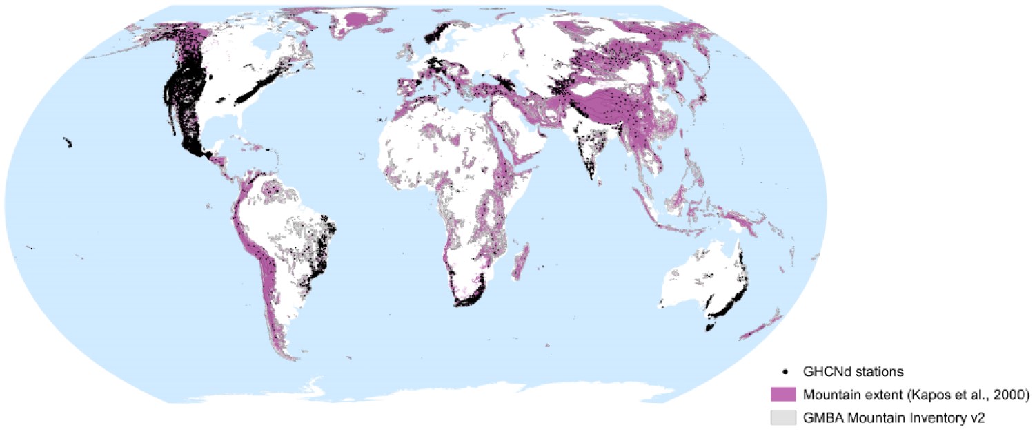
In situ climatological and other data from the world's mountains are crucial for many applications. It follows that any limitations associated with the coverage of such data (e.g. limited spatial density of stations, short record lengths, lack of observations at higher elevations, etc.) can impinge upon several important activities, not least tracking ongoing change in mountain climates and reliably projecting future changes and their impacts.
Despite this situation, the fundamental coverage of in situ data coverage with respect to space, time, and elevation has not yet been comprehensively assessed globally. As such, comparing data coverage across different mountain regions, for instance, is impossible. Yet it is precisely this information that international organisations and other stakeholders require if they are able to make sound informed decisions around investing in new (and maintaining existing) in situ monitoring efforts.
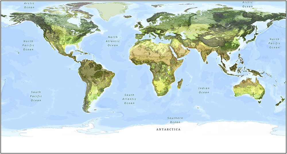
The World Terrestrial Ecosystems (WTE) map produced by Sayre et al. (2020) offers a unique spatial representation of terrestrial ecosystems. However, several important questions must be answered to determine its utility across a range of spatial scales in mountainous terrain.
This project, which is led by Eurac Research, Italy, and is funded by Microsoft, aims to exploit the power of cloud computing, sophisticated data-driven algorithms, and recent high-resolution satellite imagery to both evaluate and improve (e.g., via downscaling) the WTE map in mountainous areas.

Until recently, little consensus currently existed regarding which variables should be considered absolute observation priorities for monitoring and understanding the drivers, responses, and impacts of ongoing climate-driven change in global mountains.
To address this, a group of interdisciplinary mountain scientists built upon a workshop convened by GEO Mountains in June 2019 to rank numerous potentially relevant variables according to their perceived importance.

Effective monitoring of biodiversity in mountainous areas must consider the unique nature of such environments and the complex systems they host.
A workshop in 2020 brought together several experts to identify the key processes associated with ecological and biodiversity change in mountains, which associated variables should be considered priorities for measuring and reporting to provide reliable information to stakeholders, including policy-makers at local to global levels, and the extent to which the identified data needs can currently be met.

This project, led by the University of Geneva, seeks to map the coverage of national environmental treaties and their associated changes through time.
In this way, it should be possible to visualise the protections afforded to – and governance agreements operating in – mountain regions, as well as aspects in which they are lacking, in a spatially explicit fashion.
Numerous applications require dynamics in the count and density of human populations living in mountainous areas, as well as corresponding urbanisation dynamics, to be quantified in a transparent and reproducible fashion.
This project, which involved numerous partners, sought to address the traditional absence of such information.